An historic home on the Wallkill farm of Samuel Campbell (sold in 1793) is slated for demolition.
Noted historian, Mildred Parker Seese, included the "Old Milliken Homestead" in her book of Old Orange Homes.
 |
| Undated Photo from Seese, Old Orange Houses Volume I, 1941, p10. Note diamond-shaped window in attic. |
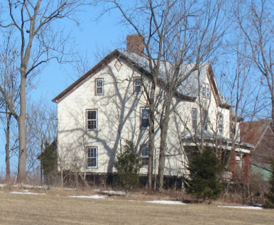
This is the home that still stands on the northeast corner of Route 208 and Coleman Road in Montgomery, New York. It is in disrepair and unoccupied. The property was once part of the Samuel Campbell farm (1773-1793) and is currently part of the Bruderhof Community. It is slated for demolition.
 |
| Picture taken by the author in March 2015. Looking from the west. Note diamond-shaped window matching the house in the Seese photo. |
 |
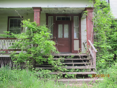
| Photo taken by the author in May 2014. Already in advanced state of decay. |
 |
| Photo taken by the author in May 2014. Front entry. |
In a prior blog, I described the ownership history of this property. It was originally part of a large 2000 acre patent granted to Archibald Kennedy in 1719. The Campbell-Barkley deed states that the part of the Kennedy patent that eventually came into Campbell hands, was 'granted' to Thomas Goldsmith (a 'Thomas Goldsmith' appeared twenty-one times in the Colden Store DayBook of 1767-8) who in turn 'granted' it to David Baldwin (could this be the same 'David Baldwin' of Newark Mountain where Samuel Campbell was living prior to coming to New York?). Samuel Campbell purchased it from Baldwin, probably in the late 1760s.
The location and boundaries of this property can be pinpointed thanks to the detailed description in the deed and the still existing stone walls that bordered the early farms.
 |
| Property Lines (red) of Campbell Farm in 1793 deed. The 'Milliken' home is just to the north of the 'Coleman Rd' label. |
Barkley already owned property to the east of this parcel. In 1826 his son sold a parcel of land to Susan Bowne which included the part of the Campbell parcel west of Route 208.
 |
| Barkley sale to Bowne in 1826. 1793 boundaries of Campbell farm in green.The boundaries are plotted on the 1862 farm map of Montgomery, NY. |
By 1862 the eastern part of the Campbell farm was part of the Peter Eager estate. He is still listed as the owner in the 1875 Atlas. The 1903 Atlas refers to the home and property as "Maple Lawn" owned by Chas. Coleman.
Milliken property appears to the west of the Bowne property on the 1862 farm map of Montgomery. The 1793 deed also described Milliken property abutting the Campbell farm on the north (above the Peter Eager parcel shown above.) However, I have found no reference other than Seese that the Millikens owned the property on which the 'Milliken' home stands. Could she be mistaken? Is this really the Peter Eager house built onto or near the original Campbell homestead?
Stay tuned.
The 1903 A. H. Mueller "Atlas of Orange county New York" shows the property/house on the NE corner of Rte 208 and Coleman Road as being owned by Chas. Coleman. The Beers 1875 Orange County Atlas shows the owner as P. Eager. However the 1851 "Map of Orange County New York" shows it as the house of Capt. P. Milliken. So I would suspect that Peter Milliken owned the property at some time prior to 1850 and it passed to Peter Eager some time after that. I notice in the 1850 census for Montgomery Twp. Peter Milliken age 75 is listed as a head of household, with a Peter Eager age 45. Presumably the Peter Eager who later owned the home. Also in the household is Phebe Norris age 42, along with two children: Hannah Wade age 15, and Andrew Taylor( mullatto) age 12. . They are listed just before Susan Bowne in the census. So I guess, it would be correct to say it was the Milliken house, Was there a home previously on that site?
ReplyDeleteApparently the Peter Eager and Phebe Norris on the 1850 census were married sometime after the 1850 census and before 1860, as they appear together on the 1860 census as husband and wife.
Bob...thanks for the comments. The Montgomery Historian also passed along a document mentioning the 1851 map after I wrote this. The age of the house has not been determined. We know the Campbells had at least two homes on the 100 acre property, but where they were is not known. The Barkleys (who purchased the property from Campbells) had many offspring and many properties. Whether the homes with the Campbell property were leased, left vacant, or used by offspring is a question. The historian is visiting the Milliken home this weekend and may find evidence of the evolution of the house (age, additions, etc.)
ReplyDeleteJay - Thanks. I hope she was able to find something out about the house. Whether or not the Campbell house was originally part of this house or not, the home seems worthy of saving as it goes back to before (apparently) 1851. It would be a shame to have it torn down.
ReplyDeleteJay - In further checking, Peter Eager inherited the farm from Peter Milliken per Peter Milliken's will of 1851. Milliken did not have children, and only had some nieces and nephews. He left Eager the farm, Phebe Norris who later married Peter Eager $2400 and various smaller sums to his nieces and nephews. How Milliken obtained the property is still not known. He appears to have been living in Montgomery in the vicinity at least from 1799. His neighbors in the tax assessments correspond with those in the immediate area. So it is possible that he was there that early.
ReplyDeletePeter Milliken married a Mary Blake, but apparently did not have any children. His parents were James Milliken and Mary Hill, grandfather Alexander Milliken. He was a Captain in the War of 1812.
Bob...would you be willing to independently determine the location of the Campbell property described in the 1793 deed? Your response seems to add weight to the claim that the Peter Milliken home is on Milliken ancestral lands. His grandfather, Alexander, is mentioned in a 1735 road commission report as having a farm just to the east of what is now 208 and the 1793 deed places Alexander's land just to the north of the Campbell lands. Maybe I have placed the northern border of the property too far north? You should have my personal e-mail and can contact me that way.
ReplyDelete