St. Modan was a 6th century Celtic monk who established a religious center in the Ruel River valley, home to Kildalvan and to the early ancestors of Joel Campbell. (See previous posts on Kildalvan) Kildalvan apparently had its own chapel ("Kil" means church) but it was likely part of St. Modan's religious community as it is just a few miles from where "Kilmodan" (the church of St. Modan) was located.
Recently, a spring was rediscovered that appeared on very early maps as "St. Modan's Well." You can read more about the discovery at the Faith in Cowal website.
The coordinates of the spring are approximately: 56.011412 -5.205267
Kildalvan was located here: 56.054845, -5.183572
The article at FaithInCowal.org suggests that quartz pebbles in the pool were "placed there most probably by long ago pilgrims as they said a prayer." As I have written before, quartz is ubiquitous in this area. A huge piece is embedded in the ruins of an ancient structure at Kildalvan.
Could Joel's ancestors have visited this holy spring, known as "St Modan's," and brought some quartz with them to place in the pool?
Tuesday, March 29, 2016


Sunday, January 24, 2016
Robert Campbell's Newark Fence
Robert Campbell was the grandfather of Joel (b ~1735), the namesake of this blogsite.
In 1714, Robert lived in Newark, New Jersey and was responsible for maintaining a section of the fence that kept grazing animals out of the town center.
Newark was founded in 1666. The homes were laid out along a main street (Broad Street) that ran almost directly south from the Training Place ("C") and Market Place ("E").
To the East of the town, was a meadow and bog known as the "Neck." A fence divided the town from this grazing area. The Neck (meadow) had natural borders on the north, east, and south. Those being the Passaic River, Newark Bay, and Bound Creek.
The earliest description of the common fence appears in the Newark Town Records of October 30, 1666. “Item, it is fully consented unto and agreed upon, that the Range of Home Lotts butting and rearing upon the Wet Swamp, called the Cedar Swamp, between the Neck and the Town; that all and every of those Home Lotts butting upon the Neck or Common Line, that they shall make and maintain from time to time, at their own proper Charge, the whole fence or Fences at the Rears of their Lotts, and not Expect an Easment, from the Neck Lands being but a Common Burden with all Home Lotts, and the condition upon which those Lotts were given out.”
The Common Fence, the responsibility for its maintenance and inspection, and the penalties for failing to maintain it, were common topics at the town meetings. The enumeration of responsibilities for surveyors, regulators, viewers, pounders, and maintainers provides researchers with some of the best lists of town residents and their relevant properties.
Fence line responsibilities were tabulated at the May 7, 1668, February 6, 1677, and October 19, 1681 town meetings. These tables contained each town member's name and the length of fence in his care. The measurement was in rods. In the 1681 entry, the rod pole was given to be 16 feet 9 inches long.
The fence was a large topic of conversation at the town meeting of April 28, 1714. The table of fence maintainers included "Robert Camell." Robert Campbell, grandfather of Joel, was known to be a resident of Newark, and owned several parcels to the west of the town center.
The list was titled “The Names of ye Persons Concerned in ye Sd Common Line, with their Proportion of fence annexed to their Names Successively, beginning at ye bound Creek and Thence Runing Northwardly to ye Main River.”
The incidents of sheep, cattle, and horses wandering into the "Home Lott" area must have been increasing. Whereas earlier fence discussions described a fence that encircled the town, this discussion focused on a fence that proceeded from the Bound Creek directly north to the "Main River" by the town (Passaic River).
The minutes of the meeting specified “That all ye Common Line fence Shall be Deemed & Esteemed Sufficient, when it is made and Maintained According to ye Act of General Assemblely, & not otherwise, Excepting from ye Bound Creek to ye Bridge by ye Two mile brook Landing, and John Bradburys by ye Main River: which Shall be made So as to Secure ye Neck & Then it Shall be accounted Sufficient, & not otherwise.”
Robert Campbell was assigned a very short section of fence, 10 links (about 7 feet). Of the 74 assignments, only four were shorter. The longest assignment went to George Day of 561 feet, the average being about 60 feet. Did Robert own property abutting the fence, or was this just an arbitrary assignment?
Summing all of the assignments, gives a fence that is 66 chains and 60 links in length, or 0.83 miles. However, from the 1916 historical map, the shortest distance between the Passaic River and Bound Creek is about 2.2 miles. This discrepancy is most likely due to a relocation of Bound Creek between 1714 and 1916.
If one assumes that the distances from the Passaic River are correct, then Robert Campbell's fence was about 2600 feet south of the river or centered at the current intersection of McCarter Highway and Green Street. [Latitude/Longitude 40.73079, -74.16864] That also places the "Two Mile Brook" a few feet south of that point. Could this be the stream shown in the lower part of the 1668 Map?
There are many uncertainties in this analysis. Bound Creek and Two Mile Brook disappeared long ago. The Neck is no longer a marsh and has been expanded into Newark Bay with fill. Broad Street still exists, but any sign of the fence is gone. The neighborhood is nothing like the "Home Lotts" of 1714. It is hard to imagine the homes and fence of 1714 when walking the sidewalk of today's Broad Street.
In 1714, Robert lived in Newark, New Jersey and was responsible for maintaining a section of the fence that kept grazing animals out of the town center.
Newark was founded in 1666. The homes were laid out along a main street (Broad Street) that ran almost directly south from the Training Place ("C") and Market Place ("E").
 |
| 1668 Map of Newark. Note that "North" is approximately to the right. The Ks denote paths leading to the meadow and J denotes the Common Fence. |
 |
| Historic Map of Newark showing streets of 1916 but also boundaries from 1666. The Bound Creek is not visible today. The Neck, which contained the bogs and meadows, is the area denoted as "Incorporated in 1836." |
The Common Fence, the responsibility for its maintenance and inspection, and the penalties for failing to maintain it, were common topics at the town meetings. The enumeration of responsibilities for surveyors, regulators, viewers, pounders, and maintainers provides researchers with some of the best lists of town residents and their relevant properties.
Fence line responsibilities were tabulated at the May 7, 1668, February 6, 1677, and October 19, 1681 town meetings. These tables contained each town member's name and the length of fence in his care. The measurement was in rods. In the 1681 entry, the rod pole was given to be 16 feet 9 inches long.
The fence was a large topic of conversation at the town meeting of April 28, 1714. The table of fence maintainers included "Robert Camell." Robert Campbell, grandfather of Joel, was known to be a resident of Newark, and owned several parcels to the west of the town center.
The list was titled “The Names of ye Persons Concerned in ye Sd Common Line, with their Proportion of fence annexed to their Names Successively, beginning at ye bound Creek and Thence Runing Northwardly to ye Main River.”
 |
| Partial list of fence assignments from Newark Town Meeting of April 28, 1714, p.127 of Records, Town of Newark 1666-1835, The New Jersey Historical Society, Newark. |
The minutes of the meeting specified “That all ye Common Line fence Shall be Deemed & Esteemed Sufficient, when it is made and Maintained According to ye Act of General Assemblely, & not otherwise, Excepting from ye Bound Creek to ye Bridge by ye Two mile brook Landing, and John Bradburys by ye Main River: which Shall be made So as to Secure ye Neck & Then it Shall be accounted Sufficient, & not otherwise.”
Robert Campbell was assigned a very short section of fence, 10 links (about 7 feet). Of the 74 assignments, only four were shorter. The longest assignment went to George Day of 561 feet, the average being about 60 feet. Did Robert own property abutting the fence, or was this just an arbitrary assignment?
Summing all of the assignments, gives a fence that is 66 chains and 60 links in length, or 0.83 miles. However, from the 1916 historical map, the shortest distance between the Passaic River and Bound Creek is about 2.2 miles. This discrepancy is most likely due to a relocation of Bound Creek between 1714 and 1916.
If one assumes that the distances from the Passaic River are correct, then Robert Campbell's fence was about 2600 feet south of the river or centered at the current intersection of McCarter Highway and Green Street. [Latitude/Longitude 40.73079, -74.16864] That also places the "Two Mile Brook" a few feet south of that point. Could this be the stream shown in the lower part of the 1668 Map?
 |
| Modern Newark Street Map showing estimated location of Robert Campbell's fence assignment based on distance from main river using measurements from April 28, 1714 records. |
Saturday, November 28, 2015
Evacuation Day - November 25, 1783
New York City was occupied by the British for over seven years during the War for Independence. It was an insult to the residents of New York State, who viewed the city as their capital and their link to commerce. Retaking the city was General Washington's objective for most of the war. During the last three years of the war, the main army wintered in a horseshoe pattern surrounding the city, waiting for an opportunity to attack. It never happened.
Sitting at the "handle" of the horseshoe was Newburgh. Washington made this area his headquarters towards the end of the war. Joel, the subject of this blog, lived close to Newburgh, and was aware of the desire to reoccupy New York. Many occupants of the city had fled in 1776 and had been Joel's neighbors during the last seven years.
After the battle of Yorktown effectively ended the war in 1781, the armies waited as peace negotiations slowly proceeded in Europe. By April of 1783 all hostilities had ceased and the negotiations for the evacuation of New York City began. It was late in the year before the date of November 25th was agreed upon.
By the autumn of 1783, many refugees had returned to the city. They were trying to reclaim homes and farms, and for the enterprising, they were already starting a brisk trade, both with the departing British and up and down the coast. One enterprising young man was Joel's neighbor, John Van Arsdale. John, a teenage veteran of the war, converted a gunboat, the Black Prince, into a cargo ship. He carried out trade between Newburgh and New York City on the newly reopened river.
It is not a tremendous stretch to imagine that every patriot had some desire to be in New York City on November 25th for what was to be the culmination of everything they had fought and sacrificed for. The ceremonies had been planned and dignitaries had been invited. It is known that John Van Arsdale was there. Who else had he brought from Newburgh in his ship? Perhaps Joel or one of Joel's sons who were closer to John's age had accompanied him.
Today, November 25, 2015, two hundred and thirty two years later, I walked the processional route. I tried to imagine what it was like so many years earlier.
My starting point was Astor Place at the "6" Line subway stop. This spot was on Bowery Lane, the main thoroughfare through the farms of Manhattan up into Harlem and eventually across the Harlem River to the road to Boston. Walking down Cooper Square, one encounters the intersection with 5th Street, 3rd Ave, and the section of the old road that still retains the name of "Bowery." Here sat a military post where Major General Henry Knox waited with the American troops who were to secure the city prior to the official entry of Washington. They halted here early in the morning of the 25th after marching from McGowan's Pass (in current Central Park). The forces waited at this post with their British counterparts. At one o'clock the British forces headed down Bowery, turned on Queen St (now Pearl) and boarded a ship to sail away.
Several blocks further down Bowery Lane stood the Bull's Head Tavern. Its location was at about 50-52 Bowery, just south of Canal St. Here Washington waited with the main entourage. They had descended from Day's Tavern in Harlem (about 126th St and 8th Ave) and had followed Knox part way to the old city boundary. It was about 2 pm when Knox returned to Bull's Head to give the signal that the city was secure, and the grand entrance began.
 |
| Evacuation day procession route on modern map. Bull's Head Tavern is red marker in upper right. Procession followed the blue line. |
 |
| Drawing of Bull's Head Tavern on Bowery Lane |
 |
| Construction at site of Bull's Head Tavern (50-52 Bowery Lane) just south of Canal Street. |
It takes some imagination to see what the procession of 1783 saw. Today the road is packed with storefronts instead of farms, most of them with signage in Mandarin. Occasionally a view will open up to the left, and the East River can be seen. Gazing back, the Met Life clock tower is visible as Bowery Lane fades into the distance.
 |
| Storefronts on Bowery Lane |
 |
| 1776 map of New York City. Current City Hall Park is located in upper middle of the map inside the triangular open space. The wide road in the upper right is Bowery Lane. Bull's Head Tavern is further up this road. North of this map is largely farm land. Queen Street (now Pearl) proceeds south from outlet of Fresh Water Pond. |
The entourage stopped briefly "near the tea-water pump." This was a source of drinking water that was at the south end of the Fresh Water Pond (now totally filled in; see in 1776 map above). This location at the corner of Pearl Street and Park Row, still feels the effects of the old spring if the "DANGER Sinking Ground " sign is any indication.
 |
| "Danger, Sinking Ground" Sign near site of old Tea Water Pump. Pearl Street and Park Row. |
 |
| Artist depiction of a "Tea Water Pump." After one enterprising water salesman christened his water source with this name, it appears to have been used generically for any water that made good tea. |
Here the public joined in the procession. George Washington and New York Governor Clinton on horse back led the procession onto Queen Street (now Pearl).
 |
| Pyle Painting of soldiers in procession. |
The path of the procession was designed to parade in front of the finest homes in the city. One of those was the Depeyster House. It was located on Queen Street (now Pearl) approximately opposite to where Cedar Street intersects. This Dutch family of merchants had a long history in the city. British officers had made this home their headquarters and Governor Clinton would make it his also. The Depeysters were loyalists and left with the British, forfeiting their vast wealth. [Catherine Depeyster would marry Peter Dubois and make her home in the same tract of land where Joel's father settled in Ulster County... the Wileman patent]
 |
| Depeyster House on Queen Street (now Pearl Street) |
 |
| Looking at site of Depeyster House from Cedar Street. It says "80 Pine" on the front, but that side of the building faces Pearl Street. |
The parade turned from Queen Street onto Wall Street, which also contained many fashionable residences. Citizens cheered from the windows of those homes. They passed the City Hall where Federal Hall now stands. The columned structure would be home to an American Mayor for the first time in over seven years.
 |
| Washington and Clinton proceeding down Wall Street. City Hall on left (now Federal Hall) |
 |
| Looking down Wall Street 232 years later. Site of City Hall on left. |
The procession turned right up Broadway and stopped in front of Cape's Tavern. Cape's Tavern stood on the west side of Broadway about opposite the intersection with Pine St. Here the procession stopped for short speeches from the "welcoming" committee and Washington and Clinton. A feu-de-joie was fired off by the troops. In a few years this Tavern would change its name to City Arms Tavern.
 |
| Cape's Tavern was located just past the Northeast corner of the Trinity Church Cemetery. There is a marker on the side of the Building that is just beyond the large one that takes up most of the frame. |
 |
| Another depiction of Washington in the procession. |
The crowd then turned around and headed to the center of power of the city, Fort George. Fort George stood where the US Customs Building (Museum of the American Indian) now stands. The procession ended here with the raising of the American flag over the fort. The British had left their colors flying and greased the pole. This is the setting for the legendary tale of John Van Arsdale, spoken of earlier. John was the enterprising sailor who scaled the pole and raised the stars and stripes. The hour long ceremony included a thirteen gun salute from the cannons of the fort.
 |
| 1776 Ratzer map of New York City. Fort George is the structure on the left labeled "1". The triangular park above it is Bowling Green. The wide road leading NE from Bowling Green is Broadway. The next structure on the left is Trinity Church. Cape's Tavern was located on Broadway at the top edge of this map. |
 |
| Looking from the top of Bowling Green at the site of Fort George, now the US Customs Building. |
The procession disbanded to the various establishments of the city for drinking and dancing. The dignitaries gathered at Fraunces Tavern for a dinner hosted by Governor Clinton. Fraunces Tavern stood at the same location as it does today.
 |
| Fraunces Tavern at same site as 232 years ago, Dock Street (now Pearl Street) and Broad Street. |
The evening ended with fireworks over the harbor.
I stopped at a few other sights that some of the soldiers of the Revolution would have remembered. The first was the site of the Friends Meeting House that was used as a prison hospital (NE corner of Liberty and Broadway). The second was the site of Livingston's Sugarhouse, used as a prison for American soldiers (Liberty Street between Nassau and William). In back of the Sugarhouse was the Dutch Church where the Depeysters and Dubois worshiped.
 |
| Livingston Sugarhouse (Revolutionary War Prison) with Dutch Church in background. |
 |
| Site of Livingston Sugarhouse on Crown Street (now Liberty Street). |
The Brick Church was another prison Hospital (NW corner of Nassau and Beekman). The site of the notorious Provost prison is marked by a stone table in the fenced off grass area east of City Hall. My last stop was at the window from the Rhinelander Sugarhouse that is memorialized in an alley behind the Municipal Building. Sadly, all of these sites require a bit of imagination. The only physical evidence of any of these structures is the Rhinelander window.
 |
| Window from Rhinelanders Sugarhouse. Displayed in alley behind Municipal Building. |
 |
| Rhinelanders Sugarhouse. |
For many years Evacuation Day was celebrated in grand style in New York City on November 25th. Who could forget the culmination of the War for Independence? It was the moment that the greatest city on earth was reoccupied by Americans. Sadly, it has been largely forgotten. There were no patriotic crowds as I walked the route. Bowery Lane looked more like China than the US. Strangely, a British drum and fife group performed at Federal Hall. There is one advantage to the disappearance of "Evacuation Day": I had no problem getting a table at Fraunces Tavern.
 |
| Meal at Fraunces Tavern. |
P.S. A map of the my route and related sites along the way is available here.
 |
| Procession followed the blue line. "D" is Depeyster House, "S" is Fraunces Tavern, "F" is Fort George, "E" is Cape's Tavern, "Q" is the Friends Meeting House (Prison Hospital), "O" is Livingston's Sugarhouse (Prison), "T" is the John Street Methodist Church. |
Friday, July 31, 2015
The Chemung (Wellsburg) Baptist Church
[Saturday August 4, 1804] The Chemung Baptist Church, Chemung, Tioga, New York
On this date, Eunice Campbell, the wife of Joel
Campbell Jr, was received into full fellowship in this congregation of the
Chemung Baptist Church in recognition of a letter of Dismission from the
Baptist Church at Brookfield.[i]
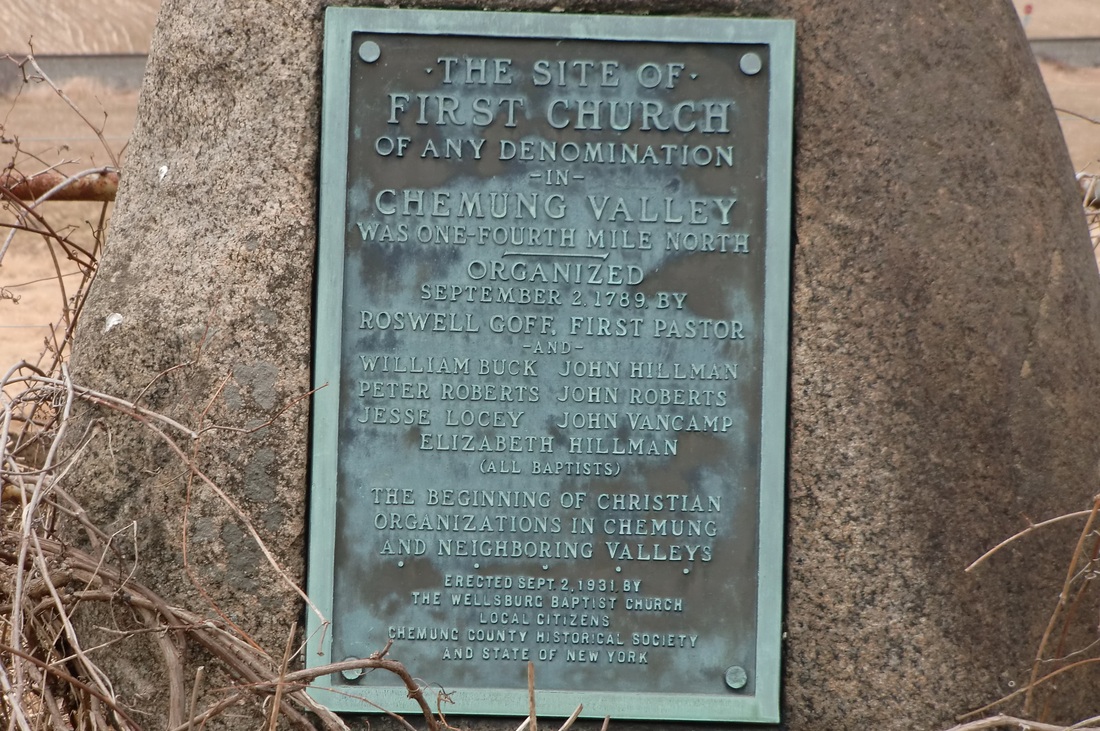
The origins of the Chemung congregation dated to fifteen years prior to Eunice's arrival. In 1789, a group of settlers who had belonged to Baptist churches in the east, now "having our lots cast in the wilderness land in the town of Chemung," founded a church. It was the first church of any denomination in the Tioga (now Chemung) River Valley. Apparently they met in a church structure which was perhaps one and the same as the log home of Roswell Goff, the first pastor. It was located south of the river just east of the current village of Wellsburg. A marker on the farm of Smith Burt, Wilawanna Road, indicates the location was about a quarter mile north in what is currently a field (north of the railroad tracks). (GPS location: 42.019061, -76.701263) (Marker at: 4045 Wilawanna Rd, Elmira, NY 14901 42.015285, -76.701163)
Did other Campbells join this church? More later.
There are at least two interesting conclusions from this fact. Firstly, the Campbells were in the valley of Bentley Creek (future Ridgebury) prior to 1805. All of the written histories say 1805 or later.
Secondly, at least one Campbell had association with the Baptists while living in Orange County.
Joel and Eunice were living in the town of Mamakating in 1800 and were probably in the area of current Bloomingburg/Wurtsboro (then called Mamacotten Hollow). From there it would have been a ten mile journey to worship at the Brookfield church. There was a closer congregation at New Vernon (about three miles from Bloomingburg) and perhaps the congregations shared the same minister. The New Vernon Primitive Baptist Church was erected in 1800 and David Campbell (nephew of Joel Sr, the namesake of this blog) is buried there.
 |
| Area of Deerpark and Mamakating. The cluster of pins on the left is the settlement of Peenpack in Deerpark. The pin labeled "J" is where Jonathan Campbell had his farm on the Neversink River. The purple pin at the top is the location of Bloomingburg and Wurtsboro (Mamacotten Hollow). The Brookfield Baptist Church is the lowest purple pin. The middle puple pin labelled "R" is the New Vernon Baptist Church. "L" is the Mt Hope Cemetery were Nathaniel Campbell is buried. The village of Montgomery is seen on the far right. The ridge of mountains passing to the SW is called the Shawangunk Ridge. You can see a zoomable version of this map at this link. |
The origins of the Chemung congregation dated to fifteen years prior to Eunice's arrival. In 1789, a group of settlers who had belonged to Baptist churches in the east, now "having our lots cast in the wilderness land in the town of Chemung," founded a church. It was the first church of any denomination in the Tioga (now Chemung) River Valley. Apparently they met in a church structure which was perhaps one and the same as the log home of Roswell Goff, the first pastor. It was located south of the river just east of the current village of Wellsburg. A marker on the farm of Smith Burt, Wilawanna Road, indicates the location was about a quarter mile north in what is currently a field (north of the railroad tracks). (GPS location: 42.019061, -76.701263) (Marker at: 4045 Wilawanna Rd, Elmira, NY 14901 42.015285, -76.701163)
 |
| Location of Chemung (Wellsburg) Baptist Church. "A" (red pin) is the location of the marker on Wilawanna Rd. "B (yellow pin) is the area of the main meeting place of this church until 1812. "C" (green pin) is the location of the new church built in 1812. "D" (blue pin) is approximate location of the Fuller farm on Bentley Creek. Campbell farms are further south on the creek. The Chemung River (then called Tioga River) at the top flows east to join with the Susquehanna. New York-Pennsylvania border bisects this map. A zoomable version of this map is here. |
Did other Campbells join this church? More later.
[i] Records of
the Chemung [Wellsburg] Baptist Church, p. 78,
http://www.joycetice.com/church/welsbg43.htm, accessed 2015-07-24; The
Brookfield Church was located in what is now Slate Hill, Wawayanda, NY. It is about 10 miles from Peenpack or
"the lower neighborhood" and slightly closer to Deerpark settlements
on the east of the ridge. This area was
part of the town of Minisink in 1800.
https://en.wikipedia.org/wiki/Primitive_Baptist_Church_of_Brookfield.
Sunday, July 19, 2015
Smithfield, Wells, Ridgeberry, Ridgebury, or Bentley Creek? All the same place?
The Fullers and Campbells arrived at the Pennsylvania valley in 1805 where they would build their homes, clear land, and farm. A man by the name of Green Bentley lived on the creek that exited the valley at its northern end. His residence was near the settlement of Southport (now Wellsburg). It is possible that by the arrival of the Campbells and Fullers in 1805, the valley stream was already being called "Bentley Creek" as it is today.
The early history of the Campbells was one of taking residence in rapidly growing parts of the country. These were frontier areas where the county and town boundaries changed rapidly to accommodate the increase in population. That was true in Wallkill/Hanover/Montgomery and in Mamakating/Deerpark. It would be no different in the valley of Bentley Creek.
Prior to 1804, this area was part of Luzerne county. As part of a large redistricting in 1804, this small part of Luzerne that contained the current townships Athens, Ridgebury, South Creek, and Wells, was moved to Lycoming.
In 1805, Bentley Creek valley sat in the township of Tioga in the county of Lycoming. The county at that time was massive, comprising, in whole or in part, the current Pennsylvania counties of Armstrong, Bradford, Centre, Clearfield, Clinton, Indiana, Jefferson, McKean, Potter, Sullivan, Tioga, Venango, and Warren.
Between 1808 and 1810, the township of Smithfield was formed. It appears to be merely a renaming of Tioga Township. If it was done to reduce confusion, it has not worked.
A new county was formed from parts of Lycoming and Luzerne on February 21, 1810. It was named "Ontario." Despite passage by the legislature, the civil organization of this county would not occur until 1812. For that reason the federal census of 1810 for the inhabitants of the valley of Bentley Creek fell within Smithfield Township in Lycoming County. Joel is not specifically mentioned in this census, but the Fullers are enumerated as are many of Joel's sons. When the county was finally organized in 1812, its name was changed from Ontario to Bradford. They also renamed the area that was "Smithfield" to Athens and Ulster. Athens being the northern most strip in the county and Ulster the next most northern.
A new township of Wells was taken out of Athens in 1813. It included the Bentley Creek area. The local assessments for Fullers and Campbells for the years 1813 to 1819 are registered in Wells Township, Bradford County.
It was not until 1818 that the township of Ridgeberry was formed from parts of Wells and Athens. The spelling varied in the early years. The spelling used in the legislative creation of the township has not been consulted, but here are a few examples of the spelling in early documents. In the 1819 assessment for Wells it was spelled "Ridgebury." In the 1820 Federal Census it was spelled "Ridgbury." In the Ridgebury assessments between 1818 and 1829 it was spelled "Ridgberry", "Ridgbery", "Ridgbury", "Rigebury", "Ridgebery", and "Ridgebury."
The History of Bradford County by David Craft spells it "Ridgeberry" in 1878.
The meticulous newspaper editor, Clement Heverly, spells it "Ridgebery" in his 1915 Pioneer and Patriot Families of Bradford County.
The concept of "correct spelling" did not really exist until the publication of Webster's Dictionary in 1828 (coincidentally the year of Joel Campbell's death). Even so, it appears the spelling of this township's name was in debate well into the 20th century.
 |
| 1819 Assessment for Wells Township where the entry of Nathaniel Campbell is crossed out as he is really in the new "Ridgebury" township. |
The early history of the Campbells was one of taking residence in rapidly growing parts of the country. These were frontier areas where the county and town boundaries changed rapidly to accommodate the increase in population. That was true in Wallkill/Hanover/Montgomery and in Mamakating/Deerpark. It would be no different in the valley of Bentley Creek.
Prior to 1804, this area was part of Luzerne county. As part of a large redistricting in 1804, this small part of Luzerne that contained the current townships Athens, Ridgebury, South Creek, and Wells, was moved to Lycoming.
In 1805, Bentley Creek valley sat in the township of Tioga in the county of Lycoming. The county at that time was massive, comprising, in whole or in part, the current Pennsylvania counties of Armstrong, Bradford, Centre, Clearfield, Clinton, Indiana, Jefferson, McKean, Potter, Sullivan, Tioga, Venango, and Warren.
Between 1808 and 1810, the township of Smithfield was formed. It appears to be merely a renaming of Tioga Township. If it was done to reduce confusion, it has not worked.
 |
| 1820 Federal Census for "Ridgbury" |
A new county was formed from parts of Lycoming and Luzerne on February 21, 1810. It was named "Ontario." Despite passage by the legislature, the civil organization of this county would not occur until 1812. For that reason the federal census of 1810 for the inhabitants of the valley of Bentley Creek fell within Smithfield Township in Lycoming County. Joel is not specifically mentioned in this census, but the Fullers are enumerated as are many of Joel's sons. When the county was finally organized in 1812, its name was changed from Ontario to Bradford. They also renamed the area that was "Smithfield" to Athens and Ulster. Athens being the northern most strip in the county and Ulster the next most northern.
A new township of Wells was taken out of Athens in 1813. It included the Bentley Creek area. The local assessments for Fullers and Campbells for the years 1813 to 1819 are registered in Wells Township, Bradford County.
It was not until 1818 that the township of Ridgeberry was formed from parts of Wells and Athens. The spelling varied in the early years. The spelling used in the legislative creation of the township has not been consulted, but here are a few examples of the spelling in early documents. In the 1819 assessment for Wells it was spelled "Ridgebury." In the 1820 Federal Census it was spelled "Ridgbury." In the Ridgebury assessments between 1818 and 1829 it was spelled "Ridgberry", "Ridgbery", "Ridgbury", "Rigebury", "Ridgebery", and "Ridgebury."
 |
| 1820 Assessment for "Ridgbery" |
The History of Bradford County by David Craft spells it "Ridgeberry" in 1878.
 |
| 1878 History by David Craft |
The meticulous newspaper editor, Clement Heverly, spells it "Ridgebery" in his 1915 Pioneer and Patriot Families of Bradford County.
 |
| 1915 Pioneer and Patriot Families by Heverly |
The concept of "correct spelling" did not really exist until the publication of Webster's Dictionary in 1828 (coincidentally the year of Joel Campbell's death). Even so, it appears the spelling of this township's name was in debate well into the 20th century.
Monday, June 29, 2015
The Newburgh Turnpike
At the end of the American Revolution, land in western New
York suddenly became more accessible.
The Indians had been driven out, treaties signed, and threats
diminished. Continental officers (and
enlisted men with long service) were awarded lands in the New York military
tracts. Other lands were available from
the government at low prices. Sometimes
all that was required was a promise to "improve" the land within a
certain time frame. According the
account of Chattie Fuller, the Campbells and Fullers (who settled on Bentley
Creek in 1805) obtained their lands "by right of possession."[i]
The main east/west thoroughfare for migration to the newly opened lands was known by many names. For those pioneers who had already made it to western New York, it was called the Newburgh turnpike, as Newburgh was where the road led. [Even though maps as far back as 1778 use the current "Newburgh" spelling, the Pennsylvanians still spell it "Newburg Turnpike."]
A zoomable map with annotations is at the link below. If possible, open it in another window to help you follow the text. https://www.google.com/maps/d/edit?mid=z7CBt6kucJTo.kLLRSGgoqpAg&usp=sharing
For those about to make the trek to the west it might have been called the "Great Bend Turnpike" or the road to Cochecton (pronounced "cuh-SHEK-ton," which was Lenape for "foaming water" or translated by others to mean "low land"). General James Clinton had proposed a similar road in 1805 to the military tracts (never built) which he called the "National Appian Way."[ii] This route took on that nickname.
Technically the route was a series of many different roads. The most easterly was the road that started at Newburgh on the Hudson River and terminated at Cochecton on the Delaware River. Its official name was the Newburgh-Cochecton Turnpike and was built and operated by a private enterprise, the Newburgh and Cochecton Turnpike company. Cochecton was chosen as the terminus as it was the site of a ford of the Delaware River to Damascus Manor on the Pennsylvania side.[iii] But it was also chosen, according to Ruttenber, because the principal stockholders had land in that area on which they had speculated.[iv]
The road from Damascus, Pennsylvania to the Great Bend in the Susquehanna River was called the Great Bend Turnpike. The enterprise that would build and operate this road was called the Company of the Coshecton [another common Pennsylvania spelling] & Great Bend Turnpike Road.[v]
At Great Bend the road connected with other well-used trails/roads that Indians had used for centuries and on which Sullivan's army had left its marks with over-packed supply wagons and artillery. The Old Lakawana Trail led from New Milford to the Great Bend. From there the well-traveled paths on either side of the Susquehanna River led to Newtown (now Elmira) and Tioga Point.[vi]
Two ferries operated across the Susquehanna at Great Bend until the first bridge was built in 1814.[vii] I suspect the Campbells made use of the ferries at that location and traveled on the north side of the Susquehanna which flows westward almost along the NY/PA border. They would have passed through the ancient Indian town of Owego, a small pioneer and merchant village in 1805.
The distance between Peenpack and Bentley Creek is about 170 miles. On horseback this could be done in 4 or 5 days. Walking with light provisions would take 8-10 days. With families, heavy supplies, and the droving of cattle/hogs/sheep, this distance could take 20-40 days to accomplish.
 |
| Signage on Pennsylvania State Road 2034 in Herrick. Note spelling. |
The main east/west thoroughfare for migration to the newly opened lands was known by many names. For those pioneers who had already made it to western New York, it was called the Newburgh turnpike, as Newburgh was where the road led. [Even though maps as far back as 1778 use the current "Newburgh" spelling, the Pennsylvanians still spell it "Newburg Turnpike."]
 |
| NY Route 114 at Cochecton. The "end" of the Newburgh-Cochecton Turnpike. |
A zoomable map with annotations is at the link below. If possible, open it in another window to help you follow the text. https://www.google.com/maps/d/edit?mid=z7CBt6kucJTo.kLLRSGgoqpAg&usp=sharing
 |
| Roads and places mentioned in this blog. Open in another window. The yellow marker on the far right is Newburgh on the Hudson River. The turnpike started at that location and ended at the red marker at Cochecton on the Delaware River. The road that continued west of the Delaware was often also called the Newburgh Turnpike, but it was chartered as the Great Bend Turnpike. It ended at the green marker, the Great Bend in the Susquehanna River. The Fullers and the Campbells were living close to "Peenpack" which is shown by the light green marker (D). Their destination of Bentley Creek is the dark blue marker on the left side. |
For those about to make the trek to the west it might have been called the "Great Bend Turnpike" or the road to Cochecton (pronounced "cuh-SHEK-ton," which was Lenape for "foaming water" or translated by others to mean "low land"). General James Clinton had proposed a similar road in 1805 to the military tracts (never built) which he called the "National Appian Way."[ii] This route took on that nickname.
 |
| Signage on Great Bend Turnpike near Pleasant Mount. The turnpike changed names along the route depending on the "most common destination" of people of the area. |
Technically the route was a series of many different roads. The most easterly was the road that started at Newburgh on the Hudson River and terminated at Cochecton on the Delaware River. Its official name was the Newburgh-Cochecton Turnpike and was built and operated by a private enterprise, the Newburgh and Cochecton Turnpike company. Cochecton was chosen as the terminus as it was the site of a ford of the Delaware River to Damascus Manor on the Pennsylvania side.[iii] But it was also chosen, according to Ruttenber, because the principal stockholders had land in that area on which they had speculated.[iv]
 |
| Delaware River from Newburgh-Cochecton Turnpike in Cochecton. |
The road from Damascus, Pennsylvania to the Great Bend in the Susquehanna River was called the Great Bend Turnpike. The enterprise that would build and operate this road was called the Company of the Coshecton [another common Pennsylvania spelling] & Great Bend Turnpike Road.[v]
 |
| One share of Coshecton & Great Bend Turnpike Stock. |
At Great Bend the road connected with other well-used trails/roads that Indians had used for centuries and on which Sullivan's army had left its marks with over-packed supply wagons and artillery. The Old Lakawana Trail led from New Milford to the Great Bend. From there the well-traveled paths on either side of the Susquehanna River led to Newtown (now Elmira) and Tioga Point.[vi]
 |
| Signage from Pennsylvania TR 945 in Gibson Township. |
Two ferries operated across the Susquehanna at Great Bend until the first bridge was built in 1814.[vii] I suspect the Campbells made use of the ferries at that location and traveled on the north side of the Susquehanna which flows westward almost along the NY/PA border. They would have passed through the ancient Indian town of Owego, a small pioneer and merchant village in 1805.
About 50 miles from Great Bend the Susquehanna River is
joined by the Tioga River flowing from the west (now called the Chemung River)
and the combined rivers turn south. At
some point the Campbells and Fullers needed to cross the Tioga River (Chemung
River). The river is only fordable at a
few spots.[viii] One spot was a mile further upstream from
where Bentley Creek entered. If they
arrived in the Fall when the water was low, they may have selected this
option. Another option would have been
to hire a ferry which operated at the town of Chemung about five miles
downstream of the junction with Bentley Creek.
In 1805, the road up Bentley Creek was probably no more than
a trail. If the Campbells and Fullers
had followed the common practice of pioneers preparing for a move, then they
had likely built this trail in a prior year.
It was common for men to leave their families for the summer to clear
land and plant at a new location. Often
they would build the start of a new home, then return home for the harvest and
spend the winter with their family.
Sometimes this routine would be repeated for multiple years until the
new land could support the move. This
might be the case if their specialty was orchards that took many years to
develop.
 |
| At the crest of a hill, before reaching Pleasant Mount, PA,, the travelers could look back and see the Catskills of New York for the last time. |
The distance between Peenpack and Bentley Creek is about 170 miles. On horseback this could be done in 4 or 5 days. Walking with light provisions would take 8-10 days. With families, heavy supplies, and the droving of cattle/hogs/sheep, this distance could take 20-40 days to accomplish.
We have no record of the route taken by the Campbells and
Fullers. We don't know how long it took
them or what time of year they traveled.
There is no indication of them arriving as one large group or making the
migration in several groups over a few years.
What we do know is that the route of the Newburgh Turnpike led a
continuous stream of settlers to the western frontiers from 1800 until the age
of the railroad.
====
The Newburgh & Cochecton Turnpike company received its
charter from the state on April 7, 1800.[ix] In reality much of this road was already
there at a much earlier date. The
company was now chartered to improve what was only a trail in places and
authorized to collect tolls. The same
can be said for the Cochecton & Great Bend Turnpike Company which received
its charter on March 29, 1804.[x] Although the road was not
"completed" until six years after the Fullers and Campbells had made
their journey, the road was laid out and was frequently traveled. It had not been improved to its
specification of "twenty foot
width." Could this mean that the
Campbells and Fullers escaped paying the tolls on the unfinished sections?
The settlement at Peenpack, where most of the Campbells were
living in 1804, was not on the turnpike.
They lived two miles from the Old Mine Road, a road believed to have
been built by the Dutch in the mid 1600s.
The current Route 209 traces this route towards Kingston, NY. The intersection with the Newburgh-Cochecton
turnpike was ten miles NE along this "Old Mine Road." This is the route I think most likely for
the start of the Campbell-Fuller trek.
However, there was another "Cochecton" road in Peenpack.
Peter Gumaer writes in his History of Deerpark that a road
to Cochecton was built in 1803 from the grist mill of Captain William Rose.[xi] Captain Rose married Mary, the daughter of
Egbert DeWitt, and inherited the DeWitt grist mill that was near the aquaduct
of the D&H canal over the Neversink River.[xii] This location is in the current hamlet of
Cuddebackville on the Old Mine Road (209). The road referred to, however did
not really go to Cochecton. Its route
is explained by Norma Schadt in the September 2008 issue of the Deerpark Diary.
She refers to a newspaper article from 1933 that states that
the "Old Cochecton Road ... ran from Roses Point to Cahoonzie, then to
Mongaup and then to Ten Mile River ...
What they called the Cochecton road turned off and went up to Cochecton."[xiii] "Roses Point" is the home of
Captain Rose and his grist mill spoken of by Gumaer. The road ran west up Prospect Hill then continued to Peenpack
Trail road, then joined existing trails when it reached the Delaware River at
the confluence of the Mongaup River. (see purple line in map.) This point was still thirty miles downriver from Cochecton. The Cochecton "road" continued up
the river about 18 miles to the entrance of "Ten Mile River" into the
Delaware. Its location is about ten
miles downriver from Cochecton.
I have often wondered if the Campbells were employed in road
building. In 1773, Joel's father's farm
straddled the road to Wilemanton (Route 208).
As such he was required to maintain the road and the small bridge that
ran over a minor stream. In 1790, Joel's location in the census is almost right
on the Newburgh Turnpike in the town of Montgomery. In 1800, Jonathan's farm is where the Lumberland Turnpike was
planned and close to the 1803 "Cochecton Road" from the Rose grist mill. Their proximity to these roads makes one
think they could have worked on them.
====
Addition roads of interest...
In 1807, the Milford and Owego Turnpike was incorporated.[xiv] This route started at Milford on the
Delaware River which was about 15 miles SW down the Old Mine Road from the
Campbell farm in Peenpack. The old road
took a direct route to Owego, passing much north of Wilkes-Barre and the
Wyoming valley route into western New York.
Perhaps this would have been an option for the Campbells if they had
left a few years later.
Another road ran past the "Campbell Flats" in
Peenpack. It would be known as the
Mount Hope and Lumberland turnpike in 1812.[xv] It went from the current Otisville to
Forestburgh. It does not appear to have
continued to Cochecton, but eventually went to a new crossing of the Delaware
at Narrowsburgh. This turnpike passed
through Campbell Flats on what is now Oakland Valley Road. Gumaer refers to the bridge where this
turnpike crossed the Neversink as being close to where Captain Abraham Westfall
built a sawmill in the 1700s "on a brook at that time termed
Bush-kill."[xvi] This is known to be on Oakland Valley Road.
[i] Charity
"Chattie" Fuller (1850-abt1920) was a granddaughter of the Fuller
patriarch who settled on Bentley Creek, Abiel Fuller. She wrote a record of Fullers and Campbells in her family. This is from page 2 of her account in the
possession of Sandra Ball.
[ii] Ruttenber,
E.M., Clark, L.H., History of Orange County, Everts & Peck, Philadelphia,
1881, p. 112.
[iii] A Brief
History of Damascus Township, http://damascustwp.org/hist.html, accessed
2015-06-27
[iv] Ruttenber,
E.M., Clark, L.H., History of Orange County, Everts & Peck, Philadelphia,
1881, p. 111.
[v] From Image
of Stock sold for the financing of the Great Bend Turnpike
[vi] Bruce,
Robert, Ancient Trails Which are Now Modern Roads, American Motorist,
March 1917, p. 17.
https://books.google.com/books?id=-Xs7AAAAMAAJ, accessed 2015-06-27.
[vii] Egle,
William Henry, History of the Commonwealth of Pennsylvania: Civil, Political
and Military ..., E. M. Gardner, Pennsylvania, 1883, p. 1089.
[viii] Friends
of the Chemung River Watershed, "The Historical Story of the Chemung
River", http://www.chemungriverfriends.org/history.php, accessed
2015-06-27.
[ix] Palmer,
Richard F., Turnpike Corporations in New York State,
http://rootsweb.ancestry.com/~nycayuga/turnpikes/index.html, accessed
2015-06-27
[x] Mathews,
Alfred, History of Wayne, Pike, and Monroe Counties, Pennsylvania, R.T. Peck
& Company, - Monroe County (Pa.),
1886, p222, available at books.google.com.
[xi] Gumaer,
Peter, A History of Deerpark, Minisink Valley Historical Society, Port Jervis,
1890, p. 136.
[xii] Gumaer,
Peter, A History of Deerpark, Minisink Valley Historical Society, Port Jervis,
1890, p. 65.
[xiii] Schadt,
Norman, Deerpark Diary, September 2008,
http://www.1863schoolhouse.org/images/diaries/sept08.pdf, accessed 2015-06-27.
[xiv] Gordon,
Thomas, A Gazetteer of the State of Pennsylvania, p.476,
https://books.google.com/books?id=mzsVAAAAYAAJ, accessed 2015-06-28
[xv] Schadt,
Norman, Deerpark Diary, March 2008, http://www.1863schoolhouse.org/images/diaries/march08.pdf,
accessed 2015-06-27.
[xvi] Gumaer,
Peter, A History of Deerpark, Minisink Valley Historical Society, Port Jervis,
1890, p. 169.
Thursday, May 28, 2015
The 1760 Farm of Samuel Campbell - His neighbors, the McCollams
The properties to the south of the Campbell Farm were discussed in a previous post. The main property to the south was purchased by John Perry in 1760, passed to the Wood family, and was deeded to Obadiah Newkirk in 1843.
The property to the northwest of the Obadiah Newkirk property (and presumably to the west of the Campbell Farm) is labeled as 99 acres belonging to E.B. Littell. Also bordering on the north at the eastern edge is the James Beattie property (Campbell Farm?). These two properties are mentioned in the 1843 deed to Newkirk as the "John Arthur and James Beattie" lands.
A description of the James Beattie lands is given in a 1815 deed from Robert Beattie to James. ["New York, Land Records, 1630-1975," images, FamilySearch (https://familysearch.org/pal:/MM9.3.1/TH-1971-32870-4108-66?cc=2078654&wc=M7HY-MW5:358136701,358689801 : accessed 28 May 2015), Orange > Deeds 1827-1828 vol GG-HH > image 135 of 545; county courthouses, New York. 1815 NOV 20 Robert Beattie to James Beattie Deed, Liber GG, p.210 )
Bob Goodwin wrote "How this land came into the possession of Robert Beatty is long and complicated and will have to be the subject of another post." We look forward to that.
The Littell lands were received by deed in 1850 from John Arthur. [1850 Elias B. Littell from John Arthur, Liber 105, p. 65, Image 316
https://familysearch.org/pal:/MM9.3.1/TH-1951-32877-15705-45?cc=2078654&wc=M7C7-QWG:358136701,359419301] The deed further states that these lands "were lately owned and occupied by Doctor Henry W. Hornbeck deceased."
The Hornbecks appear to be living on this land at least since 1820 when they appear in the Montgomery federal census. However, this land is deeded to them in 1808 by Matthew McCollam. ["New York, Land Records, 1630-1975," images, FamilySearch (https://familysearch.org/pal:/MM9.3.1/TH-1951-32871-633-97?cc=2078654&wc=M7HT-ZMS:358136701,358577401 : accessed 28 May 2015), Orange > Deeds 1807-1809 vol K-L > image 153 of 485; county courthouses, New York. 1808 deed from Matthew and Elizabeth McCollam to Henry Hornbeck, Liber K, p. 297]
I believe the census takers had problems with the McCollam name. In the 1790 census the name appeared as "John McClannen" (could he be the son of Samuel McCollam who witnessed Samuel Campbell's will in 1773?). In the 1800 census the widow McCollam was known as "Elizabeth Montfort" (this is confirmed in the deed).
The property is described as:
" ... known and distinguished in the map or plan of Wilemanton by the name of Lot number thirty and is bounded as follows that is to say,
Beginning at a small black oak sapling marked with two notches and a blaze on four sides being the southwesterly corner of lot number twenty and runs from thence
South twenty degrees West, thirty six Chains
to a stake and heap of stones on the easterly side of a hill in the line of the tract thence
South seventy degrees East, along said line twenty seven Chains and fifty links thence
North twenty degrees East, thirty six Chains and thence
North seventy degrees West, twenty seven Chains and fifty links (as the needle pointed in the year 1794) to the place of Beginning containing ninety nine acres of Land... "
This shape, size, and location match the Littell plot shown in the 1862 farm map.
It is likely the McCollams and the Campbells were neighbors for many years and maybe knew each other prior to the move from NJ to NY. As mentioned, Samuel McCollam was a witness to the will of Samuel Campbell. Perhaps there was even some intermarrying.
Another piece of the puzzle falls into place.
The property to the northwest of the Obadiah Newkirk property (and presumably to the west of the Campbell Farm) is labeled as 99 acres belonging to E.B. Littell. Also bordering on the north at the eastern edge is the James Beattie property (Campbell Farm?). These two properties are mentioned in the 1843 deed to Newkirk as the "John Arthur and James Beattie" lands.
 |
| 1862 Farm Map of SE Wileman and NE Brashier patents in Town of Montgomery, Orange County, NY. The line above Francis Littell, Hammer, and Newkirk farms is the dividing line between the Wileman and Brashier patents. |
A description of the James Beattie lands is given in a 1815 deed from Robert Beattie to James. ["New York, Land Records, 1630-1975," images, FamilySearch (https://familysearch.org/pal:/MM9.3.1/TH-1971-32870-4108-66?cc=2078654&wc=M7HY-MW5:358136701,358689801 : accessed 28 May 2015), Orange > Deeds 1827-1828 vol GG-HH > image 135 of 545; county courthouses, New York. 1815 NOV 20 Robert Beattie to James Beattie Deed, Liber GG, p.210 )
Bob Goodwin wrote "How this land came into the possession of Robert Beatty is long and complicated and will have to be the subject of another post." We look forward to that.
The Littell lands were received by deed in 1850 from John Arthur. [1850 Elias B. Littell from John Arthur, Liber 105, p. 65, Image 316
https://familysearch.org/pal:/MM9.3.1/TH-1951-32877-15705-45?cc=2078654&wc=M7C7-QWG:358136701,359419301] The deed further states that these lands "were lately owned and occupied by Doctor Henry W. Hornbeck deceased."
The Hornbecks appear to be living on this land at least since 1820 when they appear in the Montgomery federal census. However, this land is deeded to them in 1808 by Matthew McCollam. ["New York, Land Records, 1630-1975," images, FamilySearch (https://familysearch.org/pal:/MM9.3.1/TH-1951-32871-633-97?cc=2078654&wc=M7HT-ZMS:358136701,358577401 : accessed 28 May 2015), Orange > Deeds 1807-1809 vol K-L > image 153 of 485; county courthouses, New York. 1808 deed from Matthew and Elizabeth McCollam to Henry Hornbeck, Liber K, p. 297]
I believe the census takers had problems with the McCollam name. In the 1790 census the name appeared as "John McClannen" (could he be the son of Samuel McCollam who witnessed Samuel Campbell's will in 1773?). In the 1800 census the widow McCollam was known as "Elizabeth Montfort" (this is confirmed in the deed).

The property is described as:
" ... known and distinguished in the map or plan of Wilemanton by the name of Lot number thirty and is bounded as follows that is to say,
Beginning at a small black oak sapling marked with two notches and a blaze on four sides being the southwesterly corner of lot number twenty and runs from thence
South twenty degrees West, thirty six Chains
to a stake and heap of stones on the easterly side of a hill in the line of the tract thence
South seventy degrees East, along said line twenty seven Chains and fifty links thence
North twenty degrees East, thirty six Chains and thence
North seventy degrees West, twenty seven Chains and fifty links (as the needle pointed in the year 1794) to the place of Beginning containing ninety nine acres of Land... "
This shape, size, and location match the Littell plot shown in the 1862 farm map.
It is likely the McCollams and the Campbells were neighbors for many years and maybe knew each other prior to the move from NJ to NY. As mentioned, Samuel McCollam was a witness to the will of Samuel Campbell. Perhaps there was even some intermarrying.
Another piece of the puzzle falls into place.
Subscribe to:
Posts (Atom)