Friday, July 31, 2015

The Chemung (Wellsburg) Baptist Church

[Saturday August 4, 1804]   The Chemung Baptist Church, Chemung, Tioga, New York

On this date, Eunice Campbell, the wife of Joel Campbell Jr, was received into full fellowship in this congregation of the Chemung Baptist Church in recognition of a letter of Dismission from the Baptist Church at Brookfield.[i]

There are at least two interesting conclusions from this fact.  Firstly, the Campbells were in the valley of Bentley Creek (future Ridgebury) prior to 1805.  All of the written histories say 1805 or later.

Secondly, at least one Campbell had association with the Baptists while living in Orange County. 

Joel and Eunice were living in the town of Mamakating in 1800 and were probably in the area of current Bloomingburg/Wurtsboro (then called Mamacotten Hollow).  From there it would have been a ten mile journey to worship at the Brookfield church.  There was a closer congregation at New Vernon (about three miles from Bloomingburg) and perhaps the congregations shared the same minister.  The New Vernon Primitive Baptist Church was erected in 1800 and David Campbell (nephew of Joel Sr, the namesake of this blog) is buried there.

Area of Deerpark and Mamakating.  The cluster of pins on the left is the settlement of Peenpack in Deerpark.  The pin labeled "J" is where Jonathan Campbell had his farm on the Neversink River.  The purple pin at the top is the location of Bloomingburg and Wurtsboro (Mamacotten Hollow).  The Brookfield Baptist Church is the lowest purple pin.  The middle puple pin labelled "R" is the New Vernon Baptist Church.  "L" is the Mt Hope Cemetery were Nathaniel Campbell is buried.  The village of Montgomery is seen on the far right.  The ridge of mountains passing to the SW is called the Shawangunk Ridge.  You can see a zoomable version of this map at this link.

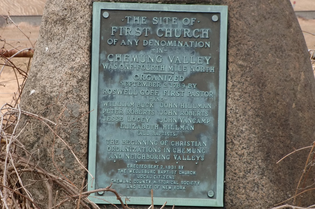
The origins of the Chemung congregation dated to fifteen years prior to Eunice's arrival.  In 1789, a group of settlers who had belonged to Baptist churches in the east, now "having our lots cast in the wilderness land in the town of Chemung," founded a church.  It was the first church of any denomination in the Tioga (now Chemung) River Valley.  Apparently they met in a church structure which was perhaps one and the same as the log home of Roswell Goff, the first pastor.   It was located south of the river just east of the current village of Wellsburg.  A marker on the farm of Smith Burt, Wilawanna Road, indicates the location was about a quarter mile north in what is currently a field (north of the railroad tracks).  (GPS location:  42.019061, -76.701263)  (Marker at: 4045 Wilawanna Rd, Elmira, NY 14901  42.015285, -76.701163)

Location of Chemung (Wellsburg) Baptist Church.  "A" (red pin) is the location of the marker on Wilawanna Rd.  "B (yellow pin) is the area of the main meeting place of this church until 1812.  "C" (green pin) is the location of the new church built in 1812.  "D" (blue pin) is approximate location of the Fuller farm on Bentley Creek.   Campbell farms are further south on the creek.  The Chemung River (then called Tioga River) at the top flows east to join with the Susquehanna.  New York-Pennsylvania border bisects this map.  A zoomable version of this map is here.

Did other Campbells join this church?  More later.


[i] Records of the Chemung [Wellsburg] Baptist Church, p. 78, http://www.joycetice.com/church/welsbg43.htm, accessed 2015-07-24; The Brookfield Church was located in what is now Slate Hill, Wawayanda, NY.  It is about 10 miles from Peenpack or "the lower neighborhood" and slightly closer to Deerpark settlements on the east of the ridge.  This area was part of the town of Minisink in 1800.  https://en.wikipedia.org/wiki/Primitive_Baptist_Church_of_Brookfield.

Sunday, July 19, 2015

Smithfield, Wells, Ridgeberry, Ridgebury, or Bentley Creek? All the same place?

The Fullers and Campbells arrived at the Pennsylvania valley in 1805 where they would build their homes, clear land, and farm.    A man by the name of Green Bentley lived on the creek that exited the valley at its northern end.  His residence was near the settlement of Southport (now Wellsburg).  It is possible that by the arrival of the Campbells and Fullers in 1805, the valley stream was already being called "Bentley Creek" as it is today.

1819 Assessment for Wells Township where the entry of Nathaniel Campbell is crossed out as he is really in the new "Ridgebury" township.

The early history of the Campbells was one of taking residence in rapidly growing parts of the country.  These were frontier areas where the county and town boundaries changed rapidly to accommodate the increase in population.  That was true in Wallkill/Hanover/Montgomery and in Mamakating/Deerpark.  It would be no different in the valley of Bentley Creek.

Prior to 1804, this area was part of Luzerne county.  As part of a large redistricting in 1804, this small part of Luzerne that contained the current townships Athens, Ridgebury, South Creek, and Wells, was moved to Lycoming.

In 1805, Bentley Creek valley sat in the township of Tioga in the county of Lycoming.  The county at that time was massive, comprising, in whole or in part, the current Pennsylvania counties of Armstrong, Bradford, Centre, Clearfield, Clinton, Indiana, Jefferson, McKean, Potter, Sullivan, Tioga, Venango, and Warren.

Between 1808 and 1810, the township of Smithfield was formed.  It appears to be merely a renaming of Tioga Township.  If it was done to reduce confusion, it has not worked.

1820 Federal Census for "Ridgbury"

A new county was formed from parts of Lycoming and Luzerne on February 21, 1810.  It was named "Ontario."   Despite passage by the legislature, the civil organization of this county would not occur until 1812.  For that reason the federal census of 1810 for the inhabitants of the valley of Bentley Creek fell within Smithfield Township in Lycoming County.  Joel is not specifically mentioned in this census, but the Fullers are enumerated as are many of Joel's sons.  When the county was finally organized in 1812, its name was changed from Ontario to Bradford.  They also renamed the area that was "Smithfield" to Athens and Ulster.  Athens being the northern most strip in the county and Ulster the next most northern.

A new township of Wells was taken out of Athens in 1813.  It included the Bentley Creek area. The local assessments for Fullers and Campbells for the years 1813 to 1819 are registered in Wells Township, Bradford County.

It was not until 1818 that the township of Ridgeberry was formed from parts of Wells and Athens. The spelling varied in the early years.  The spelling used in the legislative creation of the township has not been consulted, but here are a few examples of the spelling in early documents.  In the 1819 assessment for Wells it was spelled "Ridgebury."  In the 1820 Federal Census it was spelled "Ridgbury."  In the Ridgebury assessments between 1818 and 1829 it was spelled "Ridgberry", "Ridgbery", "Ridgbury", "Rigebury", "Ridgebery", and "Ridgebury."


1820 Assessment for "Ridgbery"

The History of Bradford County by David Craft spells it "Ridgeberry" in 1878.

1878 History by David Craft

The meticulous newspaper editor, Clement Heverly, spells it "Ridgebery" in his 1915 Pioneer and Patriot Families of Bradford County.


1915 Pioneer and Patriot Families by Heverly

The concept of "correct spelling" did not really exist until the publication of Webster's Dictionary in 1828 (coincidentally the year of Joel Campbell's death).  Even so, it appears the spelling of this township's name was in debate well into the 20th century.